 Mount Pirongia is the highest mountain in the
Waikato region, and I’ve hiked to the summit once before and wanted to do it
again. The first time I walked up, there was an old DoC (Department of
conservation) hut and some really nice camp sites but they had since built a
new 20 bed hut at the summit so I wanted to check that out. I had previously
walked up the Tirohanga Track which is possibly the easiest way to the summit,
then back down the Mahaukaura Track (a difficult track across a ridgeline). Links the the tracks here. It
was about 20km and took the better part of 10 hours, it was a lot harder than I
had expected. Being the way that I am I wanted to hike up via the longest track
to stay the night on the summit so I planned to take the bell track.
Mount Pirongia is the highest mountain in the
Waikato region, and I’ve hiked to the summit once before and wanted to do it
again. The first time I walked up, there was an old DoC (Department of
conservation) hut and some really nice camp sites but they had since built a
new 20 bed hut at the summit so I wanted to check that out. I had previously
walked up the Tirohanga Track which is possibly the easiest way to the summit,
then back down the Mahaukaura Track (a difficult track across a ridgeline). Links the the tracks here. It
was about 20km and took the better part of 10 hours, it was a lot harder than I
had expected. Being the way that I am I wanted to hike up via the longest track
to stay the night on the summit so I planned to take the bell track.The bell track is approximately 18km with a sign posted time of 8-12 hours for serious trampers. I set off with my bag weighing 16kg (4 kg of that was water) and the first half of the track was quite enjoyable. The first side track was a small set of limestone caves to walk through which was something quite cool to do. The next little side track was about 3 hours in, the tallest tree in the forest at 66m tall which again was a nice sight to check out. After another hour I got to the half way point, a small clearing/campsite where I took a breather for half an hour.
It was around this point that my toe started hurting. I had injured it the weekend before walking 20km along a beach, and this toe had previously been injured training parkour. The big toe joint was starting to hurt from overuse, but I just had to push on, keeping my mechanics as good as I could.
Sidenote: If you injure a big toe joint don’t turn your foot out to save the big toe joint, you will mess up your knee and hip mechanics, I’ve made this mistake before.
 |
| 7 hours in and I still have to climb this |
The track also got much rougher and less well sign posted at this point as well as progressively muddier. With about an hour to go to the cone I thought I would be walking mostly low gradient, then I caught a glimpse of the cone through the trees, I had a lot of uphill left to go. It was a very rough climb over rocks and through mud to the cone, and then the same to the hut, with very little board walk before reaching the hut.
I had originally planned to set up a tarpaulin and sleep under that but I was so worn out from 8 hours of hard tramping and with no one else in the hut I decided to take the easy indoor option. When I woke up the next morning my toe was still stiff and swollen and the track I was taking down to my car was 3-5 hours but I had to stuck it up and just do it. Again the track was quite rough and muddy but easier that the hike up, and reasonably enjoyable despite my toe.
Once I go back to my car I could barely walk, my big toe was swollen almost solid. It took several days to come right so I really need to address this problem joint in the future.
I really enjoy doing overnight hikes, I like getting out for a solid 8 hours of low level moving around and being out in nature. This hike was really hard, I enjoyed it but it wasn’t enjoyable at the time (if they makes sense). It’s another element to my fitness, and a lot of fun to ‘train’ because it’s really not training at all. I think the fitter I get doing these kinds of hikes the more enjoyable they will become as the weight of the pack, and the gradient of the track matter less as I get stronger.
Note: I try to keep my posts around 500-1000 words (closer to 500) but if you want to read some longer content post in the comments or on facebook because I could easily write around the 1500 work mark for some of these posts.
 |
| Some berries at the start |
 |
| The very first campsite at the bottom of the track |
 |
| Hook grass everywhere |
 |
| Lots of mud |
 |
| Looking weary |
 |
| Finally board walk |
 |
| 6am |
 |
| Looking back to the cone |
 |
| From the Summit |
 |
| From the summit |
 |
| The walk down |
 |
| It was so close I could have touched it |
 |
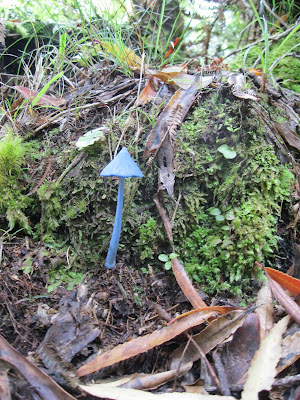
| Entoloma Hochstetteri. |
 |
| Back down at the start |


No comments:
Post a Comment